Čelarevo
Tourism
Official Website: http://sh.wikipedia.org/wiki/%C4%8Celarevo
Website Introducing the Settlement: http://sr.wikipedia.org/wiki/%D0%A7%D0%B5%D0%BB%D0%B0%D1%80%D0%B5%D0%B2%D0%BE
Cultural Tourism
- Cultural and historical monuments
The baroque castle and park Dundjerski: http://www.vojvodinaonline.com/sr/detalji_gde.php?id=584&look=2
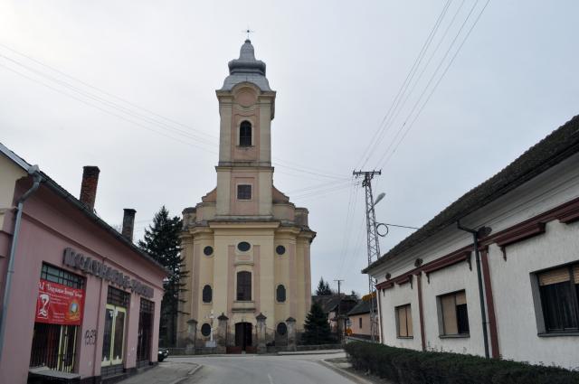
The Roman Catholic Church of the Blessed Virgin Mary: http://www.vojvodinaonline.com/sr/detalji_gde.php?id=982&look=2
The archaeological site ”Čibska šuma” : http://www.vojvodinaonline.com/sr/detalji_gde.php?id=580&look=2
- Museums
Museum of beer in Celarevo: http://www.pivnica.net/muzej-piva-u-celarevu/530/Regular cultural programmes:
http://www.turizambackipetrovac.com/sta-videti.php
Kočić days in Celarevo: http://www.kultura-vojvodina.org.rs/index.php?option=com_content&task=view&id=64&Itemid=90
Eco tourism, excursions
Park of Nature in Celarevo - Castle Park in Celarevo: http://www.vojvodinaonline.com/sr/detalji_gde.php?id=772&look=2
Gastro tourism
Days of Beer in Celarevo: http://www.toobap.rs/sr/vesti/148:najava-dani-piva-u-celarevu
Other Services
- pharmacy shop
http://www.imenik.rs/info.php?id=4830
- doctor’s office
http://privredni-imenik.com/firma/22304-zdravstvena_stanica
- tourist information bureau
http://www.turizambackipetrovac.com/
Accomodation
Tavern “Carp”: http://www.cardasaran.co.rs/
Informations
|
|
Settlement name |
Čelarevo |
|
Population |
5423 inhabitants |
|
|
Area |
33, 7 km2 |
|
|
Administrative status |
village |
|
|
Location of settlement centre |
45° 16‘N, 19° 32‘E |
|
|
Height of settlement centre |
88 m |
Settlement Celarevo, together with its soil, is situated in Southeast border part of Bac,a Palanka Municipality. In that part atar of Celarevo stretches to the border of the Municipality of Bački Petrovac. That is the terrain of South Backa, where this region goes to the Danube ashore, which is the border toward Srem.That means that Celarevo belongs to the group of Southeast and Danubien settlements.The settlement itself, Celarevo was built in the farest South edge loess terrace, or on one of its capes, which is closing to the Danube on 700 m. The position of the settlement on the edge of loess terrace is a part of the group of edgy settlements of this relief element, butit is more important that the location secures the settlement from the floods. For the Northern part of atar it is significant the channel Karavukovo-Bački Petrovac, which can be used for meliracione and sailing purposes.
The soil of Celarevo has the boundaries to the North with Backi Maglic (Municipality of Backi Petrovac), to the East there is terrain of Glozan (Municipality of Backi Petrovac), to the South over the Danube there is Susek (Municipaltiy of Beocin) and to the West Backa Palanka.
The Danube in the border part of atar flows the length of 2,7 km, and in that part has made several river islands and sandbanks, and the most famous are Velika ada, Zečije ostrvo, terrain of flooding forest Poloj. On Celarevos soil the greates surface takes the type of meadow soil (around 2/3).
As the often migrations are characterized the whole Backa, it is the same case for Celarevo. In this place the populations were chenging even from ancient period, there were discovered the traces of the old cultures. On the both sides of the Danube there were Roman legions and many barbarian nations. The Great early-medieval settlement and necropolis (8 –10 century) on the site „Ciglana“ near Celarevo, points to significant number of the present residents. There are many traces of Slavs, or Serbian presence, and presence of Turks and Hungarians in this place. On the soil of Celarevo there were discovered the traces of prehistorical necropolis and the finds of the later ancient period. We can tell about continuity of life in this place, although there were many people come and go. Exavations point to life of Avars here, but also Khazars. The first written trace about the settlement Cib (Ceb) comes from 1292 when it was menitioned as one of the county of Bac.
Source: www.wikipedia.org
Gallery