Spantov
Tourism
Official Website: www.comunaspantov.ro
Website Introducing the Settlement: http://www.ghidulprimariilor.ro/business.php/PRIMARIA-SPANTOV/41666/, www.comunaspantov.ro
Cultural and Conference Tourism
- Built heritage (local importance): http://www.calarasi.djc.ro/ObiectiveDetalii.aspx?ID=1363&lacas=true, http://www.calarasi.djc.ro/ObiectiveDetalii.aspx?ID=1362, http://vacanteromanesti.wordpress.com/2009/08/04/tichete-vacanta-calarasi-cheque-vacances
- Museum:
http://www.crispedia.ro/Aurel_Mihale
- Monasteries, churches:
http://www.calarasi.djc.ro/ObiectiveDetalii.aspx?ID=1363&lacas=true
Ecotourism, excursions
- Natura 2000:
http://natura2000.mmediu.ro/situri-natura-2000.html, http://natura2000.mmediu.ro/site/67/rosci0131.html
Sports
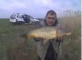
- Lake:
http://www.pescuitmania.ro/loc-dunare-ulmeni-spantov-657.htm
- Eurovelo:
Other Services
- police
- doctor on duty
http://www.doctorbun.ro/unitati-medicale/loc/spantov/#lista_unitati
- post office
http://www.orar.info/orar--4857--Posta_Romana_Oficiu_Spantov__Sat_Spantov_Calarasi.html
Informations
|
|
Settlement name |
Spantov |
|
Population |
4632 inhabitants |
|
|
Area |
67,67 ha |
|
|
Administrative status |
commune |
|
|
Location of settlement centre |
44° 07’ N, 26° 47’ E |
|
|
Height of settlement centre |
11 m |

The Spantov Commune is situated in the south of the Calarasi County and the south-east of the country along the Danube between the Olteniţa Municipality and the Călăraşi Municipality.
The Spantov Commune is situated in the south-east zone on the final and the lowest terrace of the Romanian Plateau above the level of the Danube Meadow. It is included in the Călăraşi County since the establishment of the county in 1981.
Its neighbours are as follows: the Ulmeni Commune (Valea lui Soare Village) in the west, the Danube River in the south (state border with the Republic of Bulgaria), the Chiselet Commune in the east, the Ciomuleasa Forest in the north.
The Commune has direct connection with the Olteniţa Municipality (15 km far in the west) and the Călăraşi Municipality (55 km far to the east) by travelling on DN 31 national road.
The capital city, Bucharest, can be reached by travelling on the DN 31 national road between the Olteniţa Municipality and the Spanţov Commune and on the DN 4 national road to Olteniţa Municipality and the Bucharest Municipality (63 km) or on the Spanţov – Olteniţa national road and the Olteniţa-Bucharest railway line (50 km).
The Spanţov Commune consists of five villages located not far from one another along the DN 31 national road: the Gradiştea (former Cremenea) Village, the Cetatea Veche (former Tatina) Village, the Spanţov Village, the Stancea Village and the Clinciu Village.
The surrounding zone of the commune offers a picturesque view receiving visitors for both hunting and fishing, and recreation.
The south border of the Commune consists of marshes and brooks, and the Danube that maintains moisture in the flood meadow and a fertile land surrounding the Commune. The geographical location of the Commune and other factors affect the flora that grows in the surrounding area of the Spanţov Commune. The soil is suitable for the growth of water-loving plants.
In the north of the Commune, 12 km far from the Commune, the Ciomuleasa Forest lies, a relic of the ancient woods that formed the Baragan forest steppe. The south of the forest, named Tătineanca together with the Cetatea Veche (late Tatina) Village and the agricultural lands that separate them were at the beginning of the Middle Ages the property of a woman landowner after which the settlement took its name. Spreading over 1,100 ha, the forest has been declared a nature monument since 1936, because of both its fauna and flora, and in 1976, it captured the attention of the national programme for preservation and development of the forest stock.
Specific activities in the area: Agriculture: animal husbandry and farming, Fishing
Tourist attractions: “Malul Comorii” Archaelogical Site, “Aurel Mihale” Memorial House
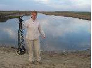
The Spanţov Channel Lake
Source: www.comunaspantov.ro
Gallery