Öttevény
Tourism
Official Website: http://www.otteveny.hu/
Website Introducing the Settlement:http://hu.wikipedia.org/wiki/%C3%96ttev%C3%A9ny
Cultural and Conferance Tourism
- heritage site (national importance), built heritage (local importance) http://www.muemlekem.hu/muemlek?id=4630
Sport
- fishpond, lake
Öttevény Lake: (http://www.terkep.net/horgasz/images/Terkep/felugro/G/G111.html)
Other Services
- pharmacy shop
http://www.mapinform.hu/city/otteveny/13/
- doctor’s office
http://www.otteveny.hu/index.php?option=com_content&task=view&id=39&Itemid=56
- post office
http://www.mapinform.hu/city/otteveny/1/
- e-point
http://www.otteveny.hu/index.php?option=com_content&task=view&id=57&Itemid=74
- restaurant
http://otteveny.restaurant.hu/
Accomodation
http://online-szallas.hu/szallasajanlatok/reszletek/21_foldvary_kastelyszalloda/
Informations
|
|
Settlement name |
Öttevény |
|
Population |
2 874 inhabitants |
|
|
Area |
2 367 ha |
|
|
Administrative status |
village |
|
|
Location of settlement centre |
47.73000, 17.48300 |
|
|
Height of settlement centre |
110- 120 m |

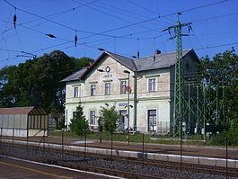
Öttevény is at a distance of 10 km to the west from Győr, between the right bank of the Mosoni Danube and the Flood plain of River Rábca. The main route 1 crosses it, but it is also accessible by the M1 motorway or on the Budapest-Hegyeshalom-Rajka route by rail. The settlement is first mentioned in a certificate in 1210. At the end of 14th century the village was owned by the greatest landlord family of the Tóköz and Szigetköz, the Héderváry family. Later, in the 15th century it became the asset of the Szentgyörgyi counts. In 1701 Germans were settled in the village, who merged into the Hungarian nation only during several hundreds of years.
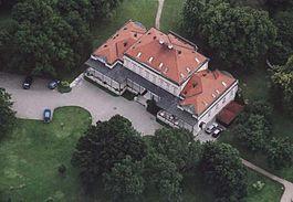
It is worth to visit the catholic church of the village built in 1786. The monument erected in memory of the heroes fallen in World War II was erected in the park next to it. The evangelic church was sanctified in 1929. A hotel expects the visitors in the renovated Földváry Castle. In excess to the relaxation and wellness services it offers sporting facilities (cycling, tennis). Both Hungarian specialities and foreign dishes are available in its restaurant. Fishing and Internet access (eMagyarország point) is also provided at the settlement. In March each year, together with the Village Day a May Picnic is held, where besides the diversified programs a cooking competition is also organised. Already for three years there is a dove and decorative bird exhibition in the village.
Sources: http://www.otteveny.hu/, http://hu.wikipedia.org/, http://www.vendegvaro.hu/
Gallery