Kisbajcs
Tourism
Official Website: http://www.kisbajcs.hu/
Website Introducing the Settlement:http://hu.wikipedia.org/wiki/Kisbajcs
http://www.iranymagyarorszag.hu/info/kisbajcs/
Other Services
- doctor’s office
http://www.kisbajcs.hu/index.php?option=com_content&task=view&id=76&Itemid=72
- post office
http://www.dimo.hu/hu/cegek/6379/Postahivatal/Posta/Kisbajcs
- e-point, internet café
http://www.emagyarorszag.hu/ugyfelkereso_reszletek.ivy?offid=C2960327-5AF6-49DA-BC9D-C8363C700890
Informations
|
|
Settlement name |
Kisbajcs |
|
Population |
820 inhabitants |
|
|
Area |
874 ha |
|
|
Administrative status |
village |
|
|
Location of settlement centre |
47.75000, 17.68330 |
|
|
Height of settlement centre |
110- 112 m |

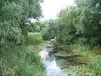
Kisbajcs is situated 2 km northeastwardly from Győr, at a distance of one and a half km from the banks of both the Big and the Moson Branches of Danube. By car it is accessible from Győr on the by-pass to Nagybajcs. If your choose to come by bus, there is a scheduled line each our to it. The first mention in writing was made of it, as “Boych” in 1250. When Győr was besieged, the camp of the Christian armies was here. During the Turkish occupation its inhabitants guarded the crossing places on the river. In the 19th century, the village had considerable income from milling and fishing. Floods have always posed big danger tp the village, therefore in Kisbajcs and Szőgye, another small settlement belonging to it buildings of “patics” (wattle-and-daub)-walls were built as a means of protection: this means that piles were driven in the soil and wickerwork made in between like a snake and from outside the structure was pugged. The buildings so made were flame resistant, thus, could not be burned, had very good heat insulation properties and in case of flood they were easy to rebuild. The Szavai-Channel runs alongside the road from Kisbajcs to Szőgye: its rich and diverse flora offers several peculiarities to the lovers of nature. Nádrét, one of the areas richest in game in the Szigetköz is also here.
Sources: http://www.kisbajcs.hu/, http://hu.wikipedia.org/, http://www.vendegvaro.hu/, http://szigetkozinfo.hu/, http://www.nemzetijelkepek.hu/
Gallery